HOME
- Introduction -
- Related Resources -
RESEARCH AREAS
- Embedding games -
- + Neighbourhood Games +
- - + Introduction
- - + Scenarios
- - + Data Transfer +
- - + Related Links
MORE
- My Work -
- Backseat Playground -
- Urban Tapestries -
Neighbourhood Games is funded by Proboscis as part of
the Social Tapestries research programme http://socialtapestries.net
|
DATA TRANSFER
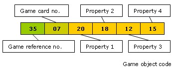
Player/Object Game Data
Key to the integration of a game across both electronic is a
means of transferring and interpreting data.
One method of recording, storing and retrieving
user data quickly and economically is by using short data strings
to either directly encode data or refer to chunks of data via
a look-up table. This was used in early digital games where dynamic
memory was limited or nonexistent. Encoded data can include waypoints,
player stats, score, level and other game data.
The example below shows a simple code that
could be associated to a player card. Data includes the game number,
the card number and statistics or properties associated with the
card, eg 'health' 'powers of observation' 'sneakiness´ and
'experience'
Map/Game Editor
a framework from/to which a game organiser/deisigner can develop
game scenarios and ourput them in a ´real´format.
In a framework such as Urban Tapestries, a map editior, custom
layer generator and simple property editor would allow the game
organiser to plan and map out the game, develop and organise assets
then print out game assets and place them according to the neighbourhood
game map. Players would simply keep track of game object codes
when picking up and dropping off items or carrying out tasks.
Player/Object Location data
Whilst player stats and observed properties can be readily encoded,
the location based element is more difficult to determine without
access to a map, GPS or other locating device. One method of introducing
location into the analogue game is for an 'online contact' (a
player who has access to a PC or the game manager) to output a
map with defined object or action location points. The map can
be grided using letters across one axis, numbers along the other
forming a simple grid system, in this way players can easily determine
locations on the map and enter these local coordinates on a host
(online contact) machine. The local map data can readily be associated
to the global mapping coordinate system by simply using a map
reference that is associated with a global coordinate and a scale
factor to interpolate player input coordinates.
Local coordinate system
1 Physical maps
1.1 A high granularity map of the neighbourhood with a simple
grid system – the map has a unique name and a zoom level
associated to that name so that any location reference entered
from the local map can easily be interpolated by the game framework.
1.2 Laminated maps posted around the neighbourhood - laminated game maps positioned around the neighbourhood where play is to be focused. Attached to trees, lampposts or other street furniture.
1.3 Chalked maps and indications - information and reference points chalked directly onto walls or pavements
2. Digital interfaces
2.1 Mobile phones
2.2 Street computers; commonly used for local information
2.3 Web phone boxes
|